Geofences in the Fleet app + new user-based reports
For better fleet management on the go, we've added geofences to the Fleet app. We've also added some great user-based reports to help managers quickly access data for a specific user rather than the whole fleet - without setting up additional user tags.
Fleets don't stop running because managers are out in the field or out of office. The new additions to our Fleet app help you stay informed from wherever you are as long as you have access to your smartphone.

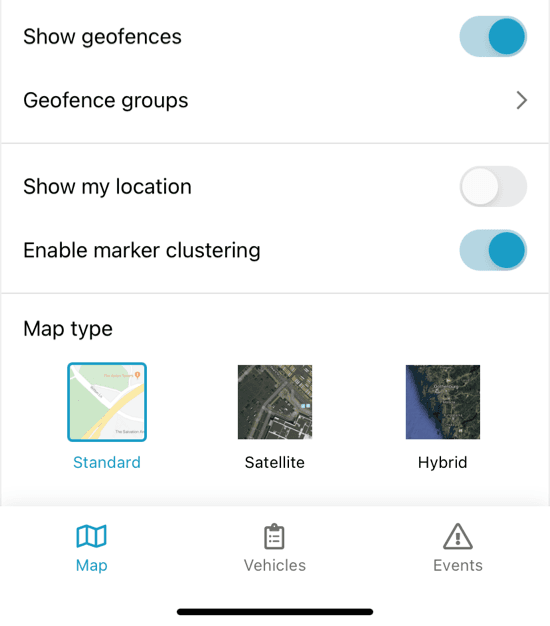
View your geofences on the go
- Toggle the geofence view on or off. If you have lots of data, you may not want to keep geofences visible 100% of the time. It's easy to show or hide geofences on the map.
- Select specific geofence group(s) that you want to be visible. Pick the geofences that you need to see to keep your map free of unnecessary data. It's easy to switch specific groups on and off.
- Your viewing settings are saved on your phone, but don't affect your application. This device-specific geofence detail keeps your data tailored to the app (and screen size) you're using.
Get user-based reports
When you need data for just one vehicle, our user-based reports give you fast and specific data.
We've added the following user-based reports:
- TR1000-U Trip & Idle detailed
- TR1001-U Trip & Idle daily
- EV1000-U Event rule
- EV1001-U Event rule total
- MT1002: maintenance service status per vehicle
This month's release also includes a new French translation, ArcGIS webmap support in the Fleet app, and security improvements. Read more in the release notes.
- acceptCookies - We use this cookie to remember if you have closed this window or not.
- country - We use this cookie to serve you country-specific data.
- gg_sessionId - This cookie helps us debug sign-up issues and general errors.
You can read more about cookies and privacy here.